


وصف لـ Trainsity Kuala Lumpur LRT KTM
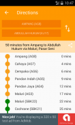
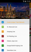
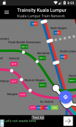
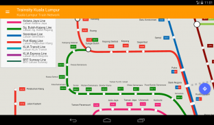
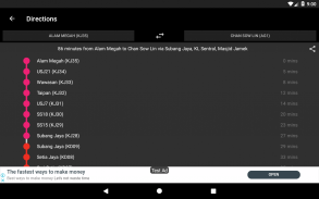
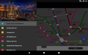
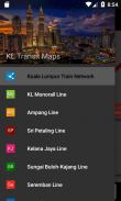
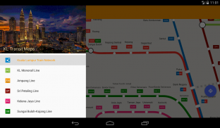
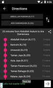
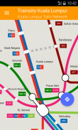
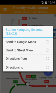
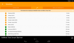
Find your way around the city of Kuala Lumpur using the high resolution vector maps of the KTM Komuter lines, RapidKL lines, and KLIA Express Rail Link lines. The maps have small file size footprints but with many levels of zoom and can work offline without connecting to the Internet. Users can click the train station labels to open Google Maps or Street View, where they can use all the functions of the Google apps to visualize the surrounding area and/or perform routing for directions. There is also an offline function to calculate the best way to travel from a station to another station with a direction breakdown and timings (which may vary from the actual travelling time).</div> <div jsname="WJz9Hc" style="display:none">العثور على طريقك في جميع أنحاء مدينة كوالا لمبور باستخدام عالية الدقة الخرائط ناقلات للخطوط KTM Komuter لل، خطوط RapidKL، وخطوط KLIA اكسبرس وصلة السكك الحديدية. خرائط لها آثار أقدام صغيرة الحجم الملف ولكن مع العديد من مستويات التكبير ويمكن أن تعمل حاليا دون الاتصال بالإنترنت. يمكن للمستخدمين النقر التسميات محطة القطار لفتح خرائط جوجل أو عرض الشوارع، حيث يمكنهم استخدام جميع وظائف تطبيقات جوجل لتصور المنطقة المحيطة بها و / أو تنفيذ توجيه للاتجاهات. هناك أيضا وظيفة حاليا لحساب أفضل طريقة للسفر من محطة إلى محطة أخرى مع تفصيل الاتجاه والتوقيت (والتي قد تختلف من وقت السفر الفعلي).</div> <div class="show-more-end">
Trainsity Kuala Lumpur LRT KTM - إصدار 2.7.200
(22-11-2023)Trainsity Kuala Lumpur LRT KTM - معلومات APK
نُسخة APK: 2.7.200الحزمة: com.dom925.trainsity.kualalumpurتطبيقات من الفئة نفسها
قد يعجبك أيضًا...


